
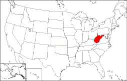
West Virginia Map
|
 |
 |
Where Is West Virginia?
The State of West Virginia, shown in red on this map, is bounded by Pennsylvania on the north and by Maryland on the northeast. The State is also bordered by Virginia to the southeast, by Ohio to the northwest, and by Kentucky to the southwest.
West Virginia Maps
West Virginia is the 41st largest state in the United States, covering a land area of 24,078 square miles (62,362 square kilometers). The state's population is dispersed across 55 counties. This West Virginia map site features road maps, topographical maps, and relief maps of West Virginia. The detailed, scrollable road map displays West Virginia counties, cities, and towns as well as Interstate, U.S., and West Virginia state highways. The pannable, scalable West Virginia street map can be zoomed in to show local streets and detailed imagery.
West Virginia Highway Map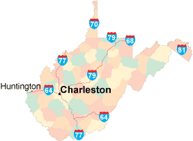 Click on the highway map thumbnail
to view a scalable West Virginia road map. |
WV Topo Map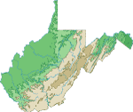 Click map to enlarge.
|
WV Relief Map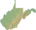 Click map to enlarge.
|
The detailed West Virginia map and the regional West Virginia map display cities, roads, rivers, and lakes as well as terrain features. The detailed map shows only the State of West Virginia, while the regional map shows West Virginia and the surrounding region.
West Virginia Infrastructure > West Virginia Airports
In 2005, the population of West Virginia was estimated at 1,814,083, which is about 75.5 people per square mile. In 2010, West Virginia's population rose to 1,852,994 people. More recently, in the 2020 census, the West Virginia population was 1,793,716. The state's major Interstate Highways include I-64, I-77, and I-79.
West Virginia Topography
West Virginia was named in honor of the English Queen, Elizabeth I, who was known as the "virgin queen". Rugged and mountainous West Virginia projects northward between West Virginia and Pennsylvania as well as eastward between Maryland and Virginia. The Ohio River runs along the state's western edge, while the eastern edge touches the Potomac River. Tourist attractions include Harpers Ferry and several limestone caverns.
For West Virginia travel and tourism information, visit the official West Virginia tourism site and West Virginia Atlas.
Other Maps of West Virginia
This West Virginia reference map shows major cities, roads, railroads, and physical features in West Virginia.Several map publishing companies offer printed maps of West Virginia. For example, Omni Resources offers several maps of West Virginia that feature points of interest, airports, and parks, as well as selected local attractions and insets of major West Virginia cities.
All rights reserved.
Certain maps hereon are © Map Resources or Digital Wisdom.
To facilitate browsing, certain external links will open in new windows.
West-Virginia-Map.org Editor, State Maps, PO Box 828, Barnegat, NJ 08005.